Saturday, July 17, 2010

Death of Tenzing Norgay Sherpa


Tenzing died of a cerebral hemorrhage in Darjeeling, West Bengal, India in 1986, aged 71 years old.

Life of Tenzing Norgay Sherpa After Everest

In January 1975, upon permission of the new king of Bhutan, Jigme Singye Wangchuck, Tenzing served as sirdar (guide) for the first American tourist party allowed into the country (see Dragonfly Wars blog and 28 June 1992 Boulder Daily Camera article, "Trek through Time," p. 1C, 3C). Brought together by a company then called Mountain Travel (and now called Mountain Travel-Sobek), the group first met Tenzing in India before beginning the trek. The official trek began in Paro, northern Bhutan, and included a visit to Tiger's Nest (Taktsang), the ancient Buddhist monastery, before returning to India via Nepal and Sikkim. Tenzing even introduced his group to the King of Sikkim (the last king of that country, which is now a part of India), and brought them to his home in India for a farewell celebration.
Tenzing later became director of field training for the Himalayan Mountaineering Institute in Darjeeling. In 1978, he founded Tenzing Norgay Adventures, a company providing trekking adventures in the Himalaya. As of 2003, the company was run by his son Jamling Tenzing Norgay, who himself reached the summit of Everest in 1996

Family life of Tenzing Norgay Sherpa


Tenzing was married three times. His first wife, Dawa Phuti, died young in 1944. They had a son, Nima Dorje, who died at the age of four, and two daughters: Pem Pem, whose son Tashi Tenzing climbed Everest, and Nima, who married a Filipino graphic designer, Noli Galang. Tenzing's second wife was Ang Lahmu, a cousin of his first wife. They had no children, but she was a foster-mother to his daughters. His third wife was Dakku, whom he married while his second wife was still alive, as allowed by Sherpa custom (see polygyny). They had three sons (Norbu, Jamling, and Dhamey), and one daughter, Deki. Other relatives include his nephews Nawang Gombu and Topgay who took part in the 1953 Everest expedition.
Tenzing is also a very popular name for male and female Tibetans or Tibetan-Nepali. The word Tenzing originates from Tibet, and means "equilibrium in all its essence" or alternately, "keeper of Buddha's teachings". Tenzing is the most common name in the Tibetan region.[citation needed]
Tenzing never learned to read or write, but he spoke several languages. His native language was either Sherpa or Tibetan (he did speak both from an early age). As an adult he learned to speak fluent Nepali.

Success on Mount Everest (Tenzing Norgay)


In 1953, he took part in John Hunt's expedition, his own seventh expedition to Everest. A member of the team was Edmund Hillary, who had a narrow escape when the ice gave way as he was moving loads up to this camp, plunging him into a crevasse. Fortunately Tenzing, who was following, thrust his ice-axe in the snow, and whipped the rope round it in good belay. It tightened just in time to prevent Hillary being smashed to pieces at the bottom of the crevasse. Thereafter Hillary began to think of Tenzing as the ideal partner in a bid for the summit.
The Hunt expedition totalled over 400 people, including 362 porters, twenty Sherpa guides and 10,000 lbs of baggage , and like many such expeditions, was a team effort.
The expedition set up base camp in March 1953. Working slowly it set up its final camp at the South Col at 25,900 feet (7,890 m). On 26 May Bourdillon and Evans attempted the climb but turned back when Evans' oxygen system failed. The pair had reached the South Summit, coming within 300 vertical feet (91 m) of the summit. Hunt then directed Tenzing and Hillary to go for the summit.
Snow and wind held the pair up at the South Col for two days. They set out on 28 May with a support trio of Alfred Gregory, Ang Nyima and a member called Lowe. The two pitched a tent at 27,900 feet (8,500 m) on 28 May while their support group returned down the mountain. On the following morning Hillary discovered that his boots had frozen solid outside the tent. He spent two hours warming them before he and Tenzing attempted the final ascent wearing 30-pound (14 kg) packs. The crucial move of the last part of the ascent was the 40-foot (12 m) rock face later named the "Hillary Step". Hillary saw a means to wedge his way up a crack in the face between the rock wall and the ice and Tenzing followed.[10] From there the following effort was relatively simple. They reached Everest's 29,028 ft (8,848 m) summit, the highest point on earth, at 11:30 am. As Hillary put it, "A few more whacks of the ice axe in the firm snow, and we stood on top."
They spent only about fifteen minutes at the summit. Hillary took the famous photo of Tenzing posing with his ice-axe, but since Tenzing had never used a camera, Hillary's ascent went unrecorded. Additional photos were taken looking down the mountain in order to re-assure that they had made it to the top and that the ascent was not faked. The two had to take care on the descent after discovering that drifting snow had covered their tracks, complicating the task of retracing their steps. The first person they met was Lowe, who had climbed up to meet them with hot soup.
Afterwards Tenzing was met with great adulation in India and Nepal. Hillary and Hunt were knighted by Queen Elizabeth, while Tenzing received either the British Empire Medal, or the George Medal from the British Government for his efforts with the expedition. It has been suggested that Indian prime minister Jawaharlal Nehru refused permission for Tenzing to be knighted.

It has been a long road ... From a mountain coolie, a bearer of loads, to a wearer of a coat with rows of medals who is carried about in planes and worries about income tax.

—Tenzing Norgay
Tenzing and Hillary were the first people to conclusively set their feet on the summit of Mount Everest, but journalists were persistently repeating the question which of the two men had the right to the glory of being the first one, and who was merely the second, the follower. Colonel Hunt, the expedition leader, declared, "They reached it together, as a team." Tenzing stressed the unity of such teams and of their achievements. He shrugged off the allegation of ever being pulled by anyone, but disclosed that Hillary was the first to put his foot on the summit. He concluded: "If it is a shame to be the second man on Mount Everest, then I will have to live with this shame." Tenzing stuck an ice axe into Mount Everest with four flags fluttering from it- of Nepal, the UK, India and the UN.

Mountaineering (Tenzing Norgay Sherpa- First ascent)


Tenzing got his first opportunity to join an Everest expedition when in 1935 he was employed by Eric Shipton leader of the reconnaissance expedition that year. As a young 19 year old his chance came when two of the others failed their medical. As a friend of Angtharkay he was quickly pushed forward and his attractive grin caught the eye of Shipton who decided to take him on.
Tenzing took part as a high-altitude porter in three official British attempts to climb Everest from the northern Tibetan side in the 1930s.
He also took part in other climbs in various parts of the Indian subcontinent, and for a time in the early 1940s he lived in what is now Pakistan, in the Chitral region as batman to a Major Chapman. His first wife died during his tenure there and was buried there. His return to Darjeeling with his two daughters took place during the Indian partition of 1947.
In 1947, he took part in an unsuccessful summit attempt of Everest. Canadian-born Earl Denman, Ange Dawa Sherpa, and Tenzing entered Tibet illegally to attempt the mountain; the attempt ended when a strong storm at 22,000 ft (6,700 m) pounded them. Denman admitted defeat and all three turned around and safely returned.
In 1952, he took part in two Swiss expeditions led by Raymond Lambert, the first serious attempts to climb Everest from the southern (Nepali) side, during which he and Lambert reached the then-record height of 28,215 ft (8,599 m).

Naming of Mount everest

With the height now established, what to name the peak was clearly the next challenge. While the survey was anxious to preserve local names if possible (e.g. Kangchenjunga and Dhaulagiri), Waugh argued that he was unable to find any commonly used local name. Waugh's search for a local name was hampered by Nepal and Tibet being closed to foreigners at the time. Many local names existed, with perhaps the best known in Tibet for several centuries being Chomolangma, which had appeared on a 1733 map published in Paris by the French geographer D'Anville. However, Waugh argued that with the plethora of local names, it would be difficult to favour one specific name over all others. So, he decided that Peak XV should be named after George Everest, his predecessor as Surveyor General of India. He wrote:
I was taught by my respected chief and predecessor, Colonel Sir George Everest to assign to every geographical object its true local or native appellation. But here is a mountain, most probably the highest in the world, without any local name that we can discover, whose native appellation, if it has any, will not very likely be ascertained before we are allowed to penetrate into Nepal. In the meantime the privilege as well as the duty devolves on me to assign…a name whereby it may be known among citizens and geographers and become a household word among civilized nations.

Various records about Mount Everest

The youngest person to climb Mount Everest was 13-year-old Jordan Romero in May 2010. Apa Sherpa holds the record for reaching the summit more times than any other person (20 times as of May 2010[update]).
The fastest ascent over the northeast ridge was accomplished in 2007 by Austrian climber Christian Stangl, who needed 16h 42min for the 10 km distance from Camp III to the summit, just barely beating Italian Hans Kammerlander's record of 17 hours, accomplished in 1996. Both men climbed alone and without supplementary oxygen. The fastest oxygen-supported ascent over the southeast ridge was Nepalese Pemba Dorjie Sherpa's 2004 climb, using 8h 10min for the 17 km route. The fastest ascent without supplementary oxygen over the southeast ridge was accomplished by French Marc Batard who reached the summit in 22h 30min in 1988.
The first descent on ski was accomplished in 2000 by Davo Karnicar.
The oldest climber to successfully reach Mt. Everest's summit is 76-year-old Min Bahadur Sherchan, who did so 25 May 2008 from the Nepal side. Sherchan beat the previous record set in 2007 by 71 year old Katsusuke Yanagisawa. The oldest climber to successfully reach Mt. Everest's summit from both sides (Nepal and Tibet) of the mountain is 60-year-old Dr. Julio Bird, a Puerto Rican cardiologist at Gundersen Lutheran Medical Center in La Crosse, Wisconsin. Dr. Bird reached the summit of Mt. Everest from the north side at 7:00am on May 17, 2010.

2008: Summer Olympic torch summit

Beginning in 2007, China paved a 130 km (81 mi) dirt road from Tingri County to Everest's Tibet base camp, at a reported cost of 150 million yuan (US$19.7 million), to accommodate growing numbers of climbers on the north side of the mountain. Upon completion, China routed the 2008 Olympic Torch Relay over this road and to the summit of Everest, via the North Col route, on the way to the 2008 Summer Olympics in Beijing.A China Telecom cellular tower near the Base Camp provides phone coverage all the way to the summit.

2005: Helicopter landing on the submit of Mount Everest

On 14 May 2005, pilot Didier Delsalle of France landed a Eurocopter AS 350 B3 helicopter on the summit of Mount Everest[45] (without any witness) and took off after about four minutes. (His rotors were continually engaged, constituting a "hover landing", and avoiding the risks of relying on the snow to support the aircraft.) He thereby set rotorcraft world records, for highest of both landing (de facto) and take-off (formally).[46]
Delsalle had also performed, two days earlier, a take-off from the South Col; some press reports suggested that the report of the summit landing was a misunderstanding of a South Col one.[47]

1996 disaster at Mount Everest

During the 1996 climbing season, fifteen people died trying to come down from the summit, making it the deadliest single year in Everest history. Eight of them died on 11 May alone. The disaster gained wide publicity and raised questions about the commercialization of Everest.
Journalist Jon Krakauer, on assignment from Outside magazine, was in one of the affected parties, and afterwards published the bestseller Into Thin Air, which related his experience. Anatoli Boukreev, a guide who felt impugned by Krakauer's book, co-authored a rebuttal book called The Climb. The dispute sparked a large debate within the climbing community. In May 2004, Kent Moore, a physicist, and John L. Semple, a surgeon, both researchers from the University of Toronto, told New Scientist magazine that an analysis of weather conditions on 11 May suggested that freak weather caused oxygen levels to plunge approximately 14%.[43][44]
The storm's impact on climbers on the mountain's other side, the North Ridge, where several climbers also died, was detailed in a first hand account by British filmmaker and writer Matt Dickinson in his book The Other Side of Everest.

Tuesday, July 13, 2010

Historical Mount Everest Facts and Trivia


These are some historical facts on Mount Everest which are relatively unknown to most people:
Prior to being named as Mount Everest, the mountain was commonly referred to as 'Peak XV' for a few years. Later on, it was formally named as 'Everest' after Col. George Everest who was the Surveyor General of India in the early 1860's. It also has a few local names such as Sagarmatha (Nepali) and Chomolungma (Tibetan).
The first people to scale this peak were Sir Edmund Hillary and Sherpa Tenzing Norgay. They managed to achieve this feat on May 29, 1953.
The first woman to have successfully scaled Mount Everest was the Japanese Junko Tabei, who did so on May 16, 1975.
Till date, an estimated 4,000 people have made attempts to climb this mountain. The fact that barely 1,000 have actually succeeded in accomplishing this tough task speaks volumes about the difficulties involved in scaling this peak.
However, although Mount Everest is taller than K2, almost all mountaineers agree that scaling K2 is much more difficult and dangerous than scaling Everest.
As per latest figures, a total of 142 people have lost their lives in trying to climb Mount Everest. Brutal weather conditions have made it very difficult to recover bodies with around 120 corpses still left lying on the mountain. The worst accident in the history of Mount Everest happened in May 1996 when a group of 11 climbers perished during a summer climbing expedition.
Most climbers attribute the Khumbu Ice Fall as being the most tricky and dangerous part of Mount Everest. It is situated between the Everest base camp and camp 1 and has so far accounted for 19 fatal casualties.
A Nepali by the name of Appa Sherpa holds the unique distinction of having climbed Everest the most number of times - a whopping 11 times!
The youngest person to climb Everest is Nepali Temba Tsheri who did so at the young age of 15. At the same time, the oldest climber to successfully scale this peak happens to be an American by the name of Sherman Bull, who did so at the ripe-old age of 64!
Another American, Erik Weihenmayer, holds the record of being the first blind person to climb Mount Everest. He achieved this feat on May 25, 2001.

Mount Everest: Native Names


Although the peak is quite popular as Mount Everest all over the world, the locals refer to it by a range of native names. In Nepal it is referred to as Mount Sagarmatha, whereas in Tibet it is referred to as the Qomolangma Peak. The Chinese refer to its as Zhumulangma Peak or Mount Chomolungma, while the Limbu tribe refers to its as Chajamlungma.

Mount Everest Location


Mount Everest is located in the Himalayan mountain range of the Indian Subcontinent, which is home to some of the biggest mountain peaks in the world. According to the coordinates, it is located at 27° 59' N latitude and 86° 55' E longitude. Mount Everest lies on the border of Nepal (Solukhumbu district) and Tibet (the Tingri County). Sir George Everest, the then Surveyor General of India, recorded the location of Mount Everest in 1841, and subsequently it was named Peak XV by Michael Hennessy. Eventually, the Royal Geographical Society changed its name from Peak XV to Mount Everest, as recommended by Andrew Waugh, in honor of Sir George Everest

Mount Everest Information


With a height of 8,848 m or 29,029 ft above the mean sea level, Mount Everest is considered to be the highest mountain on Earth. This mountain came into existence when the Himalayan mountain range was formed as a result of subduction of the Indo-Australian plate under the Eurasian plate. As the movement of these plates continues even today, the mountain continues to rise by a few centimeters every year. The peak is covered with glaciers and ice throughout the year, and the temperature here ranges between 0°F (in Summer) to -76°F (in Winter).

Which is the Tallest Mountain in the World?


The answer is simple and does tally with what you learned in your geography lessons - Yes, Mount Everest is indeed, the tallest mountain in the World, but only when measured from the mean sea level. Other than measuring height of structures from the mean sea level, there are two more methods by which we can measure the tallest structure on the planet - (a) measuring the structure from the ocean floor and (b) measuring the structure from the center of the Earth. If measured from the bottom of the ocean, the credit of being the tallest mountain goes to Mauna Kea, a volcanic crater in Hawaii, and if measured from the center of the Earth, the credit goes to Chimborazo, in the Andes mountain range. Let's get more details about each of these candidates.

Interesting Quotes About Mount Everest


Here are some interesting one-liners by some of the people who attempted to climb this massive mountain.
"Strong motivation is the most important factor in getting you to the top" ~ Sir Edmund Hillary
"Because it is there." ~ George Mallory (in response to the question, "Why do you want to climb Mount Everest?")
"I can't understand why men make all this fuss about Everest - it's only a mountain" ~ Junko Tabei Some of above-mentioned Mount Everest facts and figures are a good indication of just how difficult and treacherous it is to scale this peak

Geographical Facts About Mount Everest


Here is a collection of Mount Everest interesting facts with respect to geography:
Do you know how old this great mountain is? Researchers have suggested that Mount Everest is close to 60 million years old!
All of us would have learned in our geography classes that Mount Everest stands tall at a height of 8848 meters i.e., 29,029 feet. However, with the continuous shift in the position of the glaciers and the tectonic plates, it has been found that the height of the mountain continues to increase by approximately 2 inches every year.
For those inclined towards geographical coordinates, Mount Everest is located at 27°59′16″ North, 86°56′40″ East. In terms of territorial location, it is a part of the Himalayas and is situated along the border of Nepal and Tibet.
When measured from sea-level, Mount Everest is without a doubt, the biggest mountain peak on this planet. However, if one considers the height of a mountain from its base to its peak, there exist a few other mountains such as Mount McKinley and Mauna Kea which are taller than Everest in totality. 'Taller' than the 'tallest'? Now that's one of the most interesting facts about Mount Everest, isn't it?

History as data


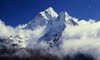
Age of Everest:- Everest was formed about 60 million years ago
Elevation:- 29,035 (8850m)-found to be 6' higher in 1999
Name in Nepal:- Sagarmatha (means: goddess of the sky)
In Tibet:- Chomolungma: (means: mother goddess of the universe)
Named after:- Sir George Everest in 1865 ,the British surveyor India. Once known as Peak 15

Location:- Latitude 27° 59' N.....Longitude 86° 56' E It's summit ridge seperates
Nepal and Tibet

First Ascent:- May 29,1953 by Sir Edmund Hillary, NZ and Tenzing Norgay, NP, via the South Col Route.

First Solo Ascent:- Aug. 20,1980, Reinhold Messner, IT, via the NE Ridge to North Face
First winter Ascent:- Feb. 17,1980 -L.Cichy and K. Wielicki, POL
First Ascent by an American:- May 1,1963, James Whittaker, via the South-Col
Mt. Everest rises a few milimeters each year due to geological forces

Everest Name:- Sir George Everest was the first person to record the height and location of Mt. Everest, this is where Mt."Everest" got its name from(In american language)

First Ascent by a Woman:- May 16,1975, Junko Tabei, JAP, via the South-Col
First Ascent by an American Woman:- Sep.29,1988, Stacey Allison, Portland, OR via the South-East Ridge

First Oxygenless Ascent:- May 8, 1978- Reinhold Messner, IT, and Peter Habeler, AUT, via the South-East Ridge

First woman to reach the summit of Mount Everest from both north & south sides:- Cathy O'Dowd (S.A.) South May 25,1996/North '99

Fastest Ascent from South:- Babu Chhiri Sherpa 34, NP-16 hours and 56 minutes (5-21-2000)

Fastest Ascent (north side):- Hans Kammerlander (IT) May,24,1996, via the standard North Col Ridge Route, 16 hours 45 minutes from base camp

Youngest person:- Temba Tsheri (NP) 15 on May,22,2001
Oldest Person:- Sherman Bull May,25,2001 -64 yrs
First Legally Blind Person:- Erik Weihenmeyer May,25,2001
Most Ascents:- Eleven, 24th May 2000 Appa Sherpa became the first person to climb Everest 11 times-Ten, Ang Rita Sherpa, Babu Chiri Sherpa all ascents were oxygen-less.

Best and Worst Years on Everest:- 1993, 129 summitted and eight died (a ratio of 16:1); in 1996, 98 summitted and 15 died (a ratio of 6½:1)

Highest cause cause of death:- Avalanches-about a (2:1) ratio over falls
Country with most deaths on mountain:- Nepal-46
Most dangerous area on mountain:- Khumbu Ice Fall-19 deaths
First ski descent:- Davo Karnicar (Slovenia) 10-7-2000
Last year without ascent:- 1974
Last year without ascent: - 1977
Corpses remaining on Everest:- about 120
Longest stay on top:- Babu Chhiri Sherpa stayed at the summit full 21 hours and a half
Largest team:- In 1975, China tackled Everest with a 410-member team.
Fastest descent:- In 1988, Jean-Marc Boivin of France descended from the top in just 11 minutes, paragliding.

Only climber to climb all 4 sides of Everest:- Kushang Sherpa, now an instructor with Himlayan Mountaineering Institute

First person to hike from sea level to summit, no oxygen:- 11th May 1990,Tim Macartney-Snape, Australian

Largest number to reach the top in one day:- 40, on May 10, 1993

Monday, July 5, 2010

History of Mt Everest

On June 8th, 1924, two British climbers—Mallory & Irvine--were spotted from below clambering over one of the major remaining obstacles of their route. The summit of Mt. Everest was only a few hours away. Swirling mists closed in and they were never seen again. Their disappearance left unanswered a question that has haunted mountaineers ever since: Had they reached the top? Even Sir Edmund Hillary—the first to certainly reach the top (and to return)—looked for signs of any possible predecessors.
Early Everesters didn’t think so. Subsequent Pre WWII expeditions during better weather and with greater resources were thwarted by the immensity of the challenge. But one thing was left out of the early pessimistic assessments—the effect of the controversial use by the two climbers of “artificial” breathing oxygen. Many contemporaries felt its use was unsporting, and angrily discounted evidence to show that climbing speeds easily doubled with its use.
The next expedition, that of 1933, retraced Mallory & Irvine’s steps and discovered one of their ice axes some 250 yards from the First Step obstacle. For decades, that was the only other clue as to their fate. In the early 1970’s I studied the best available topographic maps of Mt. Everest, and notice that the site of the ice ax lay above a large snow terrace. Would a falling climber come to rest on the “8200m Snow Terrace”? And if so, would the cameras each of them was known to be carrying, still hold the answer of how high they got? After extensive tests, Eastman Kodak thought “fully printable images” could be obtained if the camera was found intact.
The north side of Mt. Everest lies in Tibet, which was closed to foreigners after WWII. In 1960, the Chinese, who now controlled the country, launched a large expedition via the Mallory & Irvine route, and apparently succeeded in reaching the summit. There was no news of any clues. It was only in 1979 that a rumor wafted through the mountaineering ether that the secretive Japanese Alpine Club had obtained the first permission to make another attempt.
After asking them to be on the lookout for any clues on the 8200m Snow Terrace, the JAC wrote back to reveal an astounding new clue: A Chinese porter on the massive 1975 Chinese Mt. Everest expedition described finding an “English dead” on the North Face at 8100m. When he touched the body, the clothing “danced in the wind.” The day after giving the Japanese climbing leader his revelation, Wang Hung-bao died in an avalanche! Given the location at the bottom of the 8200 Snow Terrace right below the ice ax site—it could only be Mallory or Irvine.
I mounted an expedition in 1986 to search the terrace for possible clues. The expedition was snowed out and we returned empty handed—except for one new clue. Meeting with the tent-mate of the Chinese porter Wang, we learned that—in spite of official Chinese denials, yes, Wang had told his fellow climbers about discovering “a foreign mountaineer.”
The next break came with the Eric Simonson’s fabulously successful expedition of 1999. Using a search protocol developed by Everest historian Jochen Hemmleb, climber Conrad Anker wandered out from the 8100 Chinese bivouac and stumbled onto the body of George Mallory. This sensational discovery was trumpeted in newspaper headlines around the world. In spite of rope trauma mottling around Mallory’s waist indicating that they fell together, a through search of the body and surrounding terrain revealed no sign or Irvine—and no sign of a camera.
Many theories arose about what Irvine’s fate may have been since that historic discovery. The two most likely possibilities are that Irvine continued his fall over the edge of the 8200m Snow Terrace, or that Irvine only fell a short distance before the rope broke and, mortally injured, struggled on back to their highest camp—which he did not reach. One additional clue was that the two climbers left much important climbing gear (flares, lamps) in their high tent, to save weight and allow a quick dash to the summit. This suggests that only a single camera was taken, as well. This would undoubtedly have been carried by Irvine—a prolific photographer, and therefore in a position to take a snapshot of Mallory standing at their highest point, holding up his custom-made 30,000-ft altimeter.
But where was Irvine and his camera to be found? A reasonably widespread search of the ice ax fall-line turned up nothing. Over the intervening years, a number of North Face climbers have reported a number of tantalizing clues. Some acute photo analysis of random images taken on the North Face, added additional information. One of the 1960’s Chinese climbers described spotting a body lying wrapped up in a what appeared to be a sleeping bag—but off-route in a rather unusual location.